|
Day 5
Sue and Peter left the caravan park ahead of us.
We kept contact with them using
the CB sets as we headed for WA.
As I had never seen anything like the huge,
ancient ranges we passed through, I was very impressed.
Julie was
driving so I was able to take in the amazing scenery.
Peter had been reading a lot about the areas we were to travel through and therefore
turned into spots he was interested in.
Victoria River was the first.
We pulled into the Victoria River Roadhouse
situated beside the river. To me at the time, the river
was just another river with a bridge. Later I realized just how massive the
river could be, as I saw amazing pictures of the flooding in the area on the TV
news.
The surrounding ranges certainly took my eye.
The escarpment we drove alongside after we left was amazing. Huge boulders clung to the side
of the escarpment as if about to fall.
The colours were vivid
oranges through to cream, scenery I had only seen in travel books or on
calendars.
We seemed minuscule in relation to our environment, like ants
must feel as they crawl between huge rocks. The next stop
was Kurang Lookout.
From the lookout you can see the Stokes Range
in the south. The information panel told of the aboriginal interpretation of the
area.
We drove past an intersection with the Buchanan Highway, a highway later
in our trip we would travel on, unbeknown to us at the time.
Further ahead we turned and followed the Bullita\Timber Creek Road
into the Gregory National Park.
I was
wondering where we were heading - as the road became very narrow and grassy - but eventually we came to a roundabout where
we setup camp for the night.
A walking track led away from the roundabout. We followed it and in the distance was a white
substance like a lava flow. I now know it to be a
Calcite flow.
The link is to the pictures taken by buglady02 on
WEBSHOTS
Thanks to her I was able
to locate the area we visited.
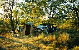
At the camp
I erected a long wire antenna between some trees and attempted to contact a friend
- who was interested in our progress - in
Hervey Bay on Amateur Radio, but
had no luck.
That night was the first night of the trip we had our meal around a
campfire.
Day 6
We backtracked and turned west again and
passed through Timber Creek.
We drove on until we reached the turn to the Keep River National Park and
began looking for the camping area.
Before we found it, we noticed a track that
was leading to a "point of interest".
After walking to the top of a hill in
the heat, we were pleasantly surprised to find a rocky outcrop that overlooked a vast area.
The rock was formed like a circular window. On the "ceiling" were
aboriginal drawings.
It was very sheltered from the elements and it was easy to
imagine the people of times gone by sheltering from the torrential downpours and
watching the flood plains below.
Also easy to imagine, was what was done to fill in time while waiting for the weather to clear
-
drawing on the surrounding rocks.
As I've
mentioned elsewhere, I no longer have pictures of a lot of this trip, therefore
I searched for a site that captures really well, what I saw.
Here is the
link.
Many thanks to the fantastic site for the use of the links.
We eventually found the
camping area and decided to stay overnight.
The camping area was well set out.
Campers parked around a fenced off circle. Toilets and fireplaces were inside
the circle.
We all had our evening meal together at one of the fireplaces.
Day 7
Sue, Julie and I set off along a track
leading away from the circle. I took my video camera and spent most of the time
trying to capture the size and colour of the rock formations.
I haven't been to the Bungle Bungles but according to people we talked to, what we saw was
like a mini Bungles Bungles. This
link shows this.
The birdlife was very audible all around. I took video of a group of Black Cockatoos
chattering away as they fed on the
grass seeds on the ground, not far off the track. I thought they would take fright and fly off, but they
weren't worried by me and just kept a wary eye on me as they ate. Their shining
black feathers occasionally lifted to show the rich red underneath.
If ever I get the chance, I would love to return.
We camped overnight again, after
returning weary and hot from the walking.
Day 8
The
Western Australia / Northern Territory
Border
wasn't much of a drive from our overnight camp.
Julie knew of the thorough search they made of vehicles and earlier had cooked
as much of the prohibited food as possible. Containers that had previously
carried prohibited material also had to be disposed of.
The staff at the border were very friendly and helpful but also did their job
well. Julie didn't like disposing of certain containers. Seeing we were from
Queensland,
they asked if we would be returning by the same route and if so, when. After she
told him we would be, and in the next couple of weeks, he suggested they store
the containers and we pick them up when passing through. She willingly took up
their offer.
We saw the turnoff to the Ord River
dam, Lake Argyle but weren't going there
at this stage of our trip. We had thoughts of going there on our return.
Not long after, we saw the outskirts of
Kununurra. We called into a shopping centre for a
few supplies, after looking around the main streets.
I had bought a GPS of the era, a
Magellan GPS 300
, which only showed your position in Lat
and Long. To use it you needed maps to
refer to. I'd rung from Townsville and was
told the maps I required of the Gibb River
area etc were available in Kununurra.
While Sue and Peter did their thing, we acquired the maps and had them
plasticised.
As it was around midday we found a park and
toilets near the
Ord River
by the
Kununurra Diversion Dam, and had
lunch.
After lunch and a rest we set off again. We
turned right at the intersection
of the
Victoria Highway
and the
Great Northern Highway
and headed North towards
Wyndham.
At the
Intersection of the
Great Northern Highway
and the
Gibb River Rd,
we turned left onto
the reason
for our trip, the Gibb River Road,
leading to the
Western Australia coast at
Derby.
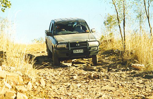
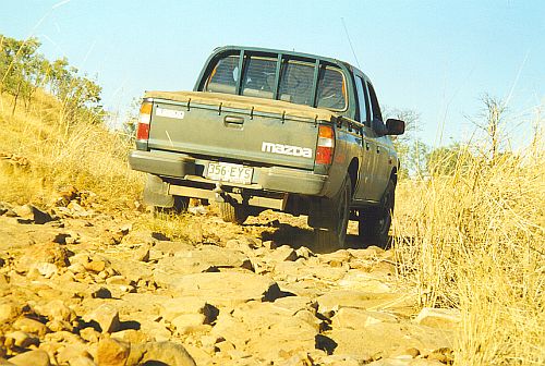
The surface then turned from bitumen to dirt corrugations.
According to our
briefing, it was supposed to be a
very isolated, remote, rough road where you needed a 4WD vehicle and all sorts of communications
and camping equipment to survive.
We soon found it WAS a very corrugated road
but I have to say that during my life as an electrician, I had travelled over
many similar roads to farms in the South Burnett area of
Queensland in a Holden Panel
Van.
4WD vehicles were very few and far between in those days in the 60's and
you did what you had to do, with the vehicles you had.
No doubt in and immediately after the "wet", before it's graded, the road
is TOTALLY different.
At the time of year we passed through, July/August,
as far as needing any or all of the abovementioned equipment after a breakdown
or whatever, as long as you were able to stop one of the huge number of other
vehicles, mostly 4WD, that roar past
towing trailers and sometimes caravans, you would certainly have no trouble
surviving.
I WAS
pleased though, to be in the air conditioned, sealed cabin
of the Mazda Bravo 4WD. It made for a very pleasant
driving experience.
At the
King River,
Peter and Sue turned left off the road and looked for a camp for the night. They
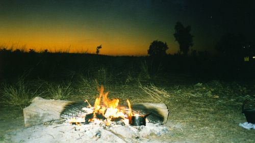
found a spot for their caravan and started a campfire.
Julie and I set up our tent and lay the
Solar Showers
out to heat in the sun.
We all ate around the campfire until the night became cold.
Back at our tent, in the dark, I threw a rope over a sapling and pulled a
Solar Shower
up.
We took turns to shower in the cold air.
The air was so cold, steam came off
Julie's body in the glow of the small fluoro light.
We then snuggled up in our double sleeping bag on our first night on The Gibb River Road.
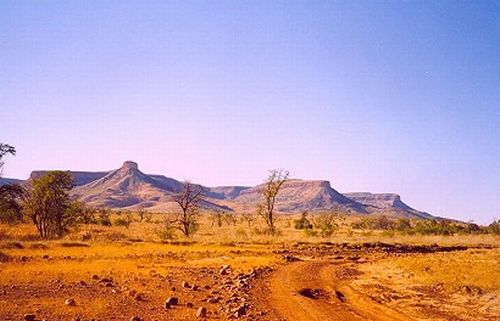
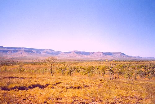
Day 9
Below are the views that greeted
us when we woke after our first night camping on the Gibb River Road.
Sheer magic.
Our campsite was a way in off the road. I walked back along the track to the
road and listened. In the still, crisp, morning air, the only sounds were of
tiny birds alarmed at my presence.
I thought how lucky I was to be in such a
beautiful spot and wondered how many other humans had stood in that same spot
since time began.
We cleared up at the campsite and drove on until
we came across a turn to
El Questro is on the
eastern perimeter of the Kimberley and runs for approximately 80 kilometres into the heart of the region.
We followed a track into El Questro homestead where there are facilities for day
visitors. We had a hamburger and drink and a look around. We weren't allowed to
go into the areas used for holidaymakers.
The best part of our
visit to El Questro, was
Zebedee
Springs
(Picture thanks to El Questro website
above). After driving back towards the main road we noticed the sign. We parked
the vehicles and followed a path through fairly ordinary bush towards a large,
orange, rocky hill. People already there were winding their way back past us and
told us about how beautiful it was up ahead.
We came across a
large, shady stand of Livingstonia Palms.
Further up the grade we came across a series of thermal
pools.The water temperature reduces as it cascades out of the pools formed
among the rocks and trunks of the palms. Kids and adults played in the water. It
really was a beautiful spot.
We cooled off in the refreshing water, knowing up
ahead there would be a lot of dust and not a lot of places to remove it.
During our trip we followed
the information from a guide book called
The KIMBERLEY - An Adventurer's Guide
by Ron & Viv Moon.
The guide book has very accurate trek notes.
Just near the Pentecost
River, the notes took us a few kilometres off the
main road.
|